Europe Map Color Separated Country: A Visual Tool for Professionals
Visual clarity and customization are essential in today’s digital and print media environments. The Europe Map Color Separated Country offers a high-quality, versatile solution for professionals across industries. Whether you're creating presentations, infographics, or marketing materials, this product provides the precision and flexibility needed to convey geographic information effectively.
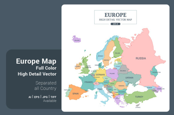
This map comes in four distinct styles: full color high detail, monotone high detail, outline stroke high detail, and outline stroke less detail on a green background. Each version serves a unique purpose, allowing users to choose the best fit for their project’s tone and function. The square format, measuring 5000x5000 pixels (42x42 cm or 16.5x16.5 inches), ensures compatibility with both digital and print platforms.
Why Visual Precision Matters
Accurate geographic representation is crucial in fields like education, journalism, and business planning. The Europe Map Color Separated Country separates each country clearly, making it easy to highlight specific regions or compare data across borders. This level of detail helps avoid confusion and supports clear communication, especially when presenting to stakeholders or publishing content online.
For educators and presenters, having a map where each country is clearly defined can make lessons or reports more engaging. It allows for easy annotation and helps audiences quickly grasp regional differences in population, economy, or cultural data.
Flexible Design for Diverse Applications
One of the standout features of this map is its adaptability. Available in AI, EPS, JPG, and TIF formats, it integrates smoothly into various workflows. Designers can scale the image without losing quality, and the vector formats allow for easy color adjustments and editing in graphic design software.
- Full color high detail is ideal for colorful infographics or educational materials where country identification is key.
- Monotone high detail works well for minimalist designs or when overlaying data without visual distraction.
- Outline stroke high detail supports technical illustrations or boundary-focused reports.
- Outline stroke less detail on green background provides a clean, natural look for environmental or geographic projects.
These variations ensure that whether you're designing a website, a printed report, or a social media post, there's a version that fits your aesthetic and functional needs.
How It Enhances Communication and Efficiency
Time is valuable, especially in fast-paced work environments. The Europe Map Color Separated Country saves time by offering a ready-to-use base that requires minimal customization. Users can quickly resize, recolor, or integrate the map into existing layouts without starting from scratch.
For marketers and content creators, this means faster turnaround on visuals for campaigns or blog posts. For business analysts, it simplifies the process of building geographic reports or dashboards. Educators can enhance their teaching materials without needing advanced design skills.
Consider a travel blogger comparing destinations across Europe. Using the full color version, they can easily highlight countries in a visually appealing way. A real estate analyst might use the monotone version to overlay economic data without overwhelming the viewer.
Supporting Creativity and Customization
Creativity thrives when tools are flexible. The ability to change colors and scale the map without quality loss opens up a wide range of design possibilities. Whether you're matching brand colors or adjusting for print contrast, the vector formats allow for seamless edits.
Freelancers and designers will appreciate the compatibility with Adobe Illustrator (AI8) and EPS files, which are standard in professional design workflows. These formats maintain quality at any size, making them suitable for everything from mobile app graphics to large-format posters.
Bloggers and small business owners can use the JPG or TIF versions for quick integration into websites or marketing materials. The high resolution ensures clarity even when zoomed in, which is important for detailed presentations or educational content.
Who Benefits Most from This Map?
While the Europe Map Color Separated Country is useful for many professionals, certain roles will find it especially valuable:
- Graphic designers can use it as a base for infographics, presentations, or website elements.
- Teachers and educators can enhance geography lessons or cross-cultural studies.
- Business analysts can visualize market data across European countries.
- Content creators can illustrate travel, cultural, or political content with clear visuals.
- Marketers can design targeted campaigns for European audiences.
Each of these groups benefits from the map’s clarity, adaptability, and professional quality. It bridges the gap between ready-made visuals and custom design, offering a balance of convenience and control.
Considerations for Best Use
While the Europe Map Color Separated Country is highly versatile, it’s important to consider your specific needs before selecting a version. For example, if you're working on a dark background, the green background version may require additional editing to blend seamlessly. Similarly, if your project requires minimal detail, the outline stroke less detail style may be more appropriate than the high-detail versions.
Users should also be aware of file size. The 5000x5000 pixel resolution is excellent for print and large-scale digital use, but it may slow down performance in some web applications. Always test the image in your intended environment to ensure compatibility and optimal loading times.
Final Thoughts
The Europe Map Color Separated Country is more than just a map—it’s a professional-grade visual tool that supports clarity, efficiency, and creativity. Whether you're building a presentation, designing an infographic, or teaching geography, this product offers the quality and flexibility needed to get the job done well. With multiple styles and formats, it adapts to your needs, helping you communicate geographic information with confidence and precision.