Australia Map Separated States: Your Ultimate Visual Resource for Custom Mapping
What Exactly Is the Australia Map Separated States?
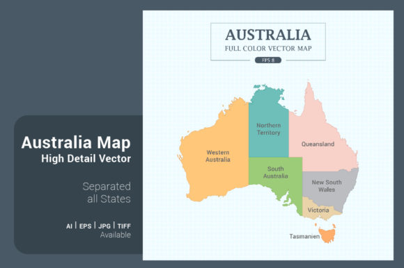
The Australia Map Many Styles in Vector is a highly versatile digital asset featuring the country’s map with each state clearly defined and separated. Available in multiple styles—full color, mono color, outline, and even map flag—this resource is designed for maximum flexibility and adaptability. With a resolution of 5000x5000 pixels and dimensions of 42x42 cm or 16.5x16.5 inches, it ensures clarity and detail whether you're using it for print or digital platforms.
Real-World Uses for the Australia Map Separated States
Whether you're a teacher, a graphic designer, a marketer, or a local business owner, the Australia Map Separated States can serve a wide variety of purposes. Here’s how different users can benefit from this adaptable map:
- Educators can use the outline or mono color versions to create engaging geography lessons. The clearly separated states make it easy for students to identify and color regions, reinforcing their understanding of Australian geography.
- Graphic designers love the vector formats (.AI8, .EPS8) because they allow for easy customization. Whether you need to highlight specific regions for a campaign or create a stylized infographic, the map can be resized and recolored without losing quality.
- Marketers and advertisers can use the full color version to represent regional data or target specific audiences in different states. For example, a national campaign can be broken down state by state, with each section tailored to local preferences or demographics.
- Local governments or tourism boards can integrate the Australia Map Separated States into brochures, websites, or presentations to visually communicate travel routes, regional attractions, or public service announcements.
Designers and Content Creators Will Appreciate the Flexibility
One of the standout features of the Australia Map Many Styles in Vector is the variety of visual options. The outline border on white background is perfect for minimalist designs, while the green background blackboard style gives a more rustic or educational feel. The square shape format also makes it easy to integrate into modern layouts without awkward cropping or distortion.
For example, if you're designing a poster for a nationwide event, the full color version helps draw attention and clearly marks where each state stands. On the other hand, if you're creating a mobile app with limited screen space, the outline or mono color versions can convey the same geographic information in a cleaner, less distracting format.
How to Choose the Right Version for Your Needs
Before selecting a version of the Australia Map Separated States, consider the following factors:
- Intended Use: Will this be for print, digital, or both? Vector formats like .AI8 and .EPS8 are best for print and scalable designs, while .JPG and .TIF are ideal for web use.
- Customization Needs: If you plan to change colors or highlight specific regions, go with a vector format. These allow for easy editing in programs like Adobe Illustrator or Inkscape.
- Visual Style: The map flag version might be perfect for a patriotic or national campaign, while the outline border on green background works well for school projects or nature-related content.
Industries That Benefit from the Australia Map Separated States
This versatile map is not limited to just one field. Here are a few industries that can make the most of it:
- Education: From primary school geography lessons to university-level research, the Australia Map Separated States offers a clear, customizable base for teaching and learning.
- Travel and Tourism: Travel agencies and bloggers can use the map to visually represent itineraries, regional attractions, or travel routes across Australia.
- Government and Public Services: Local councils or state departments can use the map to display service areas, emergency zones, or public transport routes.
- Marketing and Advertising: Whether it's for a national campaign or regional promotions, the map allows marketers to segment audiences and tailor messaging by location.
- Nonprofits and NGOs: Organizations focused on environmental or social causes can use the map to show the impact of their work across different states.
Practical Examples of the Map in Action
Here are a few real-world applications that show how useful the Australia Map Many Styles in Vector can be:
- A national health campaign uses the full color map to show which states have the highest vaccination rates, allowing viewers to quickly grasp regional differences.
- An online retail business integrates the outline version into their website to illustrate shipping zones across Australia, making it easy for customers to understand delivery areas.
- A school teacher prints the mono color map for students to color and label each state as part of a hands-on geography activity.
- A political analyst uses the vector file to overlay election results by state, creating a compelling visual representation of voter preferences.
Strengths and Limitations of the Australia Map Separated States
One of the biggest strengths of this map is its scalability. Because it's available in vector formats, it maintains quality at any size—from a small social media post to a large poster. It's also highly customizable, allowing users to adjust colors, borders, and details to suit their specific needs.
However, there are some considerations to keep in mind:
- While the .JPG and .TIF versions are great for quick use, they are not as editable as vector files. If you need to make changes to individual states or colors, stick with .AI8 or .EPS8.
- Some styles, like the blackboard background, may not be suitable for all branding or design contexts. Always preview the map in your intended layout before finalizing.
- For digital use, especially on mobile devices, ensure the file size is optimized to maintain fast load times without sacrificing quality.
Final Thoughts
The Australia Map Separated States is more than just a visual tool—it's a practical solution for a wide range of applications. Whether you're creating educational materials, marketing content, or informative infographics, having a clear, customizable map at your disposal can make a world of difference. With multiple styles, high resolution, and support for various file formats, this map is ready to meet the needs of designers, educators, marketers, and more.